Long before Mumbai came under the control of British, it was ruled by various kings, sultans and Europeans such as the Portuguese, but none of them ever thought of merging the islands of Mumbai together and form a united city. They might have thought of it, but due to the political instability and lack of funds at that time, it could not have been possible. However clever Englishmen must have hatched this plan since the city came under their control, and because of that only they must have arranged the marriage of their king to the Portuguese princess.
The East India Company appointed Gerald Aungier as Governor of Mumbai in 1671-72. He was a visionary Englishman who had recognized the importance of Mumbai. Many historians consider him as the Father of Mumbai. He was the first Englishman who gave an impetus to the development of Mumbai city of those times. Aungier had been toying with the idea of uniting the scattered islands of Mumbai into one land mass ever since he came here. He had also sought approval from his head office in England, but 'The East India Company' being a commercial enterprise which always calculated profit and loss replied that it was not possible to spend that much amount. However, Aungier and many of his successors continued their efforts.
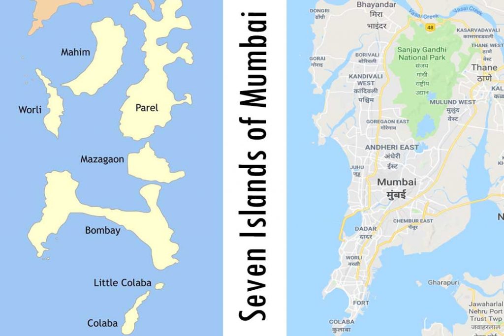
Exactly one hundred years later, in the year 1771, William Hornby assumed the office of Governor of Mumbai. By then, the city of Mumbai had grown considerably. People were migrating into the city from across India to settle here and naturally the land available for their habitation and trade started falling short. Now, however, there was no alternative but to reclaim the islands. To start with, let us first understand the situation on the island of Mumbai at that time. Colaba, Chota (Little) Colaba, Mumbai, Worli, Mahim, Parel and Mazgaon were the seven islands of Mumbai. Mumbai was the largest of these and the main stronghold of the British. Naturally, settlements and commercial establishments of those times were densely located on this island. The large human habitation after Mumbai Island was located on Mazgaon Island situated next to Mumbai across a narrow creek and other islands were comparatively sparsely populated. Mumbai and its nearest neighboring island Worli on the west coast, was around one mile apart and this area between the two used to get inundated during high tide. Out of the seven islands of Mumbai, it was the place where maximum water used to enter. If anyone wanted to go there at any time, there was no other option but to go by boat.
The water used to enter between the two islands during high tide and go right up to Mazgaon. The area between these two islands comprising Byculla, Bhendi Bazaar, Pydhonie, etc. being low lying used to be totally flooded during high tide. As a result, there was no alternative but to take a small canoe to reach areas like Mazgaon on the other side. Therefore, this area used to be permanently moist, muddy, and swampy after the tide receded. Such areas used to be the breeding ground for mosquitoes and gnats resulting in spread of many diseases. It is said that many Europeans who came to Mumbai Island for work at that time died due to illness.
William Hornby got invigorated and sent a proposal to his head office in London for getting permission and funds to construct a permanent embankment between the today’s 'Mahalakshmi' on Worli Island to the present 'Atria' Mall, in order to prevent sea water from entering inside and build a permanent road for commuting to Worli and Islands beyond it. Since he had knowledge of previous correspondence made by previous governors and the continuous refusal by the Company, this dashing man started work in 1781-82 without waiting for the Company's permission. Hornby started the work, but the question of funds arose. It is said that Hornby got in touch with a wealthy lady by the name 'Miss Rose Nesbitt 'who used to live in Mazgaon in those days and arranged funds from her. At that time, the termination of his governorship was only two-and-a-half years away.
By then the news of Hornby having started the work to block the gaps at Worli without permission had reached the London office of the East India Company. Hell broke loose! The decree was immediately issued and the envelope containing the letter of Hornby’s suspension from the governor’s post arrived at Mumbai in two months’ time. Since in those days all the postal correspondence happened by sea through boat, the voyage would easily take two-three months. Hornby received the envelope, and as per his expectation, it contained an order for his suspension. Very little work was remaining, and the new governor was not due to arrive for taking charge in the next two or three months. Hornby, without being staggered in the slightest, pressed the suspension order and kept the work in continuation and finally in 1784 the construction of this embankment and the road on it was completed and only then did he hand over his charge to the new governor.
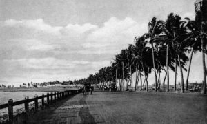
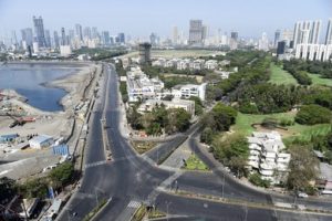
As we come down from Pedder Road and proceed towards Worli, we have to pass over a wide crescent-shaped road. On the left, far away in the sea there is the Haji Ali Dargah while on the right, Lala Lajpat Rai College, Racecourse, Sardar Vallabhbhai Patel Stadium, National Sports Complex etc. These are the various places we pass and further we cross Atria mall and reach the Municipality’s 'Love Grove Pumping Station. This beautiful road between Hira-Panna Shopping Center and 'Love Grove' is the same road which William Hornby constructed staking his own post: 'The Hornby Vellard'; today's Lala Lajpatrai Marg!! This road was named after its creator by the public of Mumbai of those times.
What exactly happened when this road and the embankment beneath it was built? Well, the wide expanse of land which we see today stretching from the Race Course and Patel Stadium to Byculla and Mazgaon in the east was created. Mr. Govind Madgaonkar has mentioned in his book 'मुंबईचे वर्णन’ (Description of Mumbai) that because of this, 40,000 acres of new land mass was created. This is the region which we today know as Central Mumbai which became the soul of hustling bustling Mumbai. Because such a large land mass was made available, naturally settlements and commercial establishments flourished there. The land which used to be a shallow, swampy wetland, the frequently occurring diseases not only got curtailed but also exterminated. The huge project of Hornby of unifying Mumbai by reclaiming land happened to be the first major civil engineering project in the country. This trend continued and all islands were reclaimed creating new lands. This is the interesting anecdote of how Mumbai acquired her own land!!
Parting Shot —
Govind Madgaonkar has mentioned that the funds required for this huge project were given to William Hornby by Ms. Rose Nesbitt, an extremely wealthy lady. In those days, this lady owned huge properties spread across all the islands of Mumbai. Even she too found it difficult to manage those properties from the point of view of commuting. She must have agreed to fund this project with a “charity through selfishness” thought that she too will get benefited from it. The famous Mahim Causeway of Mumbai was also similarly created by Lady Jamshedji with the same thought. There is a large road in Mazgaon which even today is named after Ms. Nesbitt. As we descend from the JJ Flyover and proceed towards Dadar, we come to the traffic signal in Ismail Merchant Square, before we ascend the “Khada Parsee” bridge at Byculla; the road which starts from this signal and goes up to Mazgaon is “Nesbitt Road”. On this same road are located the St. Anne’s Church and the Saint Mary’s Institute where the mortal remains of Ms. Nesbitt are buried. St. Anne’s Church was a small chapel built by Ms. Nesbitt which was later converted into a full-fledged church.
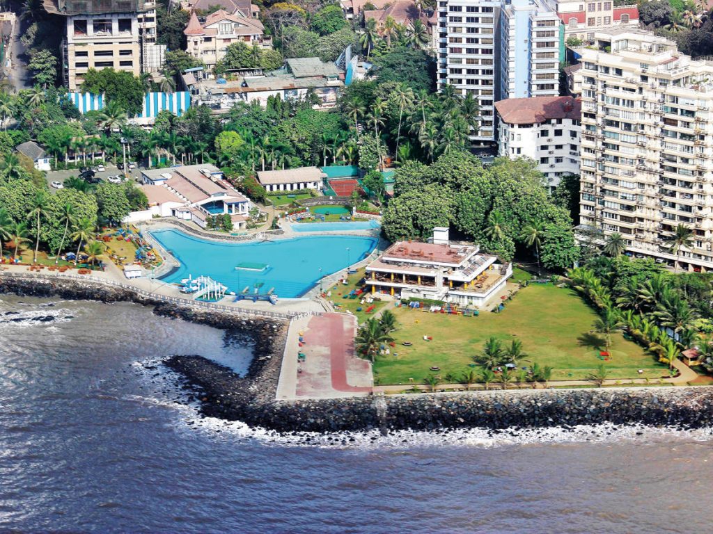
The embankment built by William Hornby gave rise to “Breach Candy”, a Mumbai residential area of the affluent and extremely wealthy citizens. The open sea between Mumbai and Worli islands used to be termed as “The Great Breach” by the British. The English word “Breach” means a ‘break’ or a ‘gap’ in Marathi. Therefore, the ‘candy’ in ‘Breach Candy’ could have been derived from the Marathi word “khindaar” meaning a “hole”. The words ‘Breach Candy’ were used to convey a meaning of a wide gap in the land near the sea. In the year 1784-85 or thereabouts, this embankment was completed and as a result large land mass was created in Mumbai and the dense population of Fort Mazgaon thinned out as they came to stay in more spacious homes in the vicinity of Peddar Road and Mahalaxmi area of today. Naturally, those that settled here were European bureaucrats, big Indian industrialists or wealthy princes and kings of erstwhile Indian kingdoms. The area saw the development of large palaces, manors and mansions and this area came to be considered as belonging to the super-wealthy people of Mumbai which continues till date. Even today, many palaces and mansions of those times are seen in this area but in dilapidated condition.
The embankment which was constructed at a cost of Rs. four to five lakhs in those times, did not just give Mumbai her ‘land’ but also paved the way for this city to turn into a megapolis. Now whenever you travel on that road, do remember William Hornby. This same road gave birth to Mahalaxmi, the Great Deity of all Mumbaikars.
@ Yeshwant Marathe